Rusty Shackleford
Automotive M.D.
not bad pg, thanks!

Well, it messed up the rhythm of the lines a bit, but I am used to writing rhythmic erotic poetry, not songs..not bad pg, thanks!
 tanks
tanks  figures they will probably close and the whole cycle will start over!
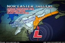
 to eastern Pennsylvania, there is going to be a heavy, wind-driven snowfall beginning Thursday and lasting into Friday morning. Roads will close through this region, and there will be downed trees and power lines. where there is still a lot of snow on the ground from previous storms. Travel over those ridges will be next to impossible from Thursday afternoon through Friday as gusty winds blow and drift snow that is falling and what is already on the ground., winds will gusts to or past 50 mph during the height of the storm. Winds will even peak up to 70 mph in some places..
")
 looks like maybe dinner at applebees tonight, mister mule a roo. friend of mine and his new dolly belle.